Introduction
ATMOSYS#
VITO's ATMOSYS air quality modelling toolbox is designed to support ambient air quality monitoring, assessment and actions aimed at improving its quality, at national, regional and urban levels.
The ATMO-Plan application#
One of the key applications within the ATMOSYS tool box is ATMO-Plan, the urban scale air quality planning application. ATMO-Plan is a user-friendly web based scenario assessment tool that is configured with baseline data upon which users perform different air quality scenarios. The application is suited to target different sources of pollution. It was originally designed to assess the impact of proposed urban mobility plans on the surrounding air quality (e.g. new road layouts, development of bypasses, ring roads or low emission zones). Additionally, it can handle (industrial) point sources to assess the impact of future modifications. Recently, the application was extended to allow the assessment of measures aimed at reducing local residential emissions.
Key Uses#
The application is typically used to support the preparation of air quality action plans in line with the European air quality ambient directive, designing LEZ's and to evaluate the impact of local clean air policies. It can also be used as a standard tool to harmonise all air quality impact assessment processes across a region (e.g. environmental permit processes and Environmental Impact Assessments (EIA)). This ensures that all assessments are based on the same modelling system and specific baseline data.
Configuration of ATMO-Plan#
Defining the purpose of the application is the first step in its configuration. When this has been agreed, a specification document is drawn up that describes any new functionalities or tailor-made developments that have been requested, together with the local data that is required for the specific region of interest. The application can be hosted by VITO but it is normally installed on the customer’s local IT infrastructure for their long term use.
The underlying models#
The FASTRACE traffic emissions model#
FASTRACE is a traffic emission model developed by VITO. It is based on COPERT, the software used worldwide to calculate emissions from road transport (developed by Emisia commissioned by the European Environment Agency (EEA)). COPERT does not provide a geographical breakdown of the calculated emissions. However high resolution air quality models require spatially disaggregated emissions. Consequently, FASTRACE was built as a COPERT based model, providing spatial allocation of emissions at street level. Below, the basic concepts of FASTRACE are described.
Computational kernel#
FASTRACE calculates emissions from road transport for all road segments in a network (network emissions), starting from mobility data and a fleet file, and emission factors based on COPERT. Emissions are then calculated as emissions (E) = vehicle kilometers (vkm) x emission factor (EF)
Mobility data, fleet, and network#
To calculate emissions, FASTRACE requires mobility data. These are delivered in two formats, fleet format and network format:
- A fleet consists of the number of vehicles per vehicle type, along with the annual mileage per vehicle type;
- A network describes the number of passing vehicles per road segment and the associated speed.
FASTRACE processes these files to vehicle kilometers (vkm) per vehicle type and road segment, which is the main input for the calculation of emissions.
Emission Factors#
Emission factors (EF) are determined based on the COPERT software. However, whereas COPERT implements complex EF functions, FASTRACE uses a look-up table containing EFs per vehicle type, road type, pollutant and speed. Interpolation of EFs from the look-up table occurs within the FASTRACE model. Configuration of the look-up table is based on a number of (full-blown) region specific COPERT runs and expert opinions. The basic EF are derived from the COPERT output. These basic EFs are supplemented as some vehicle types, in particular types that are to be expected in the near future (and thus are necessary to include in the model with respect to scenario analysis) are not yet included in COPERT. For these vehicle types EFs are inserted into the look-up table based on expert opinion, literature and specific studies.
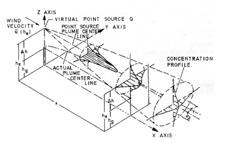
The IFDM dispersion model#
The IFDM model calculates the dispersion of pollutants in the atmosphere depending on windspeed/direction & atmospheric stability. IFDM is a bi-Gaussian dispersion model using the Bultynck-Malet dispersion parameters (Bultynck & Malet, 1972). The figure below illustrates the elements in a Gaussian dispersion model.
A Gaussian model is a simplified analytic solution to the full advection diffusion equations using meteo dependent parameterisations for the steady state plume spreading in the atmosphere. IFDM works with a source-receptor grid in which the concentration contributions from all sources are computed for each receptor grid point.
The IFDM model has been well validated for use in urban environments with several atmospheric environment papers published (W. Lefebvre, Cosemans, & Kegels, 2013; W. Lefebvre, Van Poppel, Maiheu, Janssen, & Dons, 2013; Wouter Lefebvre et al., 2011; Wouter Lefebvre & Vranckx, 2013).